6:36 pm update
Severe Thunderstorm Watch 403
|
|
 Note: The expiration time in the watch graphic is amended if the watch is replaced, cancelled or extended.
Note:
Note: The expiration time in the watch graphic is amended if the watch is replaced, cancelled or extended.
Note: Click for Watch Status Reports.
   SEL3

   URGENT - IMMEDIATE BROADCAST REQUESTED
   Severe Thunderstorm Watch Number 403
   NWS Storm Prediction Center Norman OK
   630 PM EDT Wed Jun 19 2019

   The NWS Storm Prediction Center has issued a

   * Severe Thunderstorm Watch for portions of
     Central and eastern Kentucky
     Middle to northeastern Tennessee

   * Effective this Wednesday night and Thursday morning from 630 PM
     until 200 AM EDT.

   * Primary threats include...
     Scattered damaging wind gusts to 70 mph possible
     Isolated large hail events to 1.5 inches in diameter possible.
|
|
3 pm update.
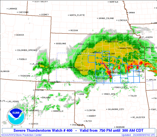
Severe Thunderstorm Watch 400
|
|
 Note: The expiration time in the watch graphic is amended if the watch is replaced, cancelled or extended.
Note:
Note: The expiration time in the watch graphic is amended if the watch is replaced, cancelled or extended.
Note: Click for Watch Status Reports.
   SEL0

   URGENT - IMMEDIATE BROADCAST REQUESTED
   Severe Thunderstorm Watch Number 400
   NWS Storm Prediction Center Norman OK
   210 PM CDT Wed Jun 19 2019

   The NWS Storm Prediction Center has issued a

   * Severe Thunderstorm Watch for portions of
     Northeast Arkansas
     Southern Illinois
     Southwest Indiana
     Western Kentucky
     Southeast Missouri
     Northwest Tennessee

   * Effective this Wednesday afternoon and evening from 210 PM
     until 900 PM CDT.

   * Primary threats include...
     Scattered damaging wind gusts to 70 mph possible
     Isolated large hail events to 1.5 inches in diameter possible
     A tornado or two possible.
|
|
The Storm Prediction Center has a Slight Risk for Western and Central Kentucky in yellow and a Marginal Risk in dark green for the entire state. Damaging winds, lighting, heavy rain, and perhaps some hail will be the main severe weather threats.
There is an
Enhanced Risk for severe weather for portions of Texas, Louisiana, and Arkansas.
The tornado threat is on the low end, but non zero at 2-5%. Now in the orange Enhanced Risk area, the tornado threat is 10%. Large hail and damaging winds is a significant threat there as well.
Timing: This afternoon and evening 3-9 pm.
Stay tuned for possible watches and warnings from your local Meteorologists.
Tropics,
Tropical Outlook for the Gulf and Atlantic over the next five days: Good, No Development.


No comments:
Post a Comment