For Central Kentucky Issued Today:
11:00 pm update. 02/12/2020.
The National Weather Service in Louisville KY has issued a
* Flood Warning for
the Rolling Fork River near Boston.
* from this evening to late Saturday night.
* At 9:30 AM Wednesday the stage was 33.7 feet.
* Flood stage is 35.0 feet.
* Minor flooding is forecast.
* Forecast...Rise above flood stage by this evening and continue to
rise to near 38.9 feet by early Friday morning. The river will fall
below flood stage by Saturday before midnight.
* Impact...At 40.0 feet...Water begins to cross low spots on some
county roads. Some homes in flood plain are cutoff.
* Flood History...This crest compares to a previous crest of 38.8
feet on Mar 16 2015.
* Rainfall of 1 to 2 inches with locally higher amounts possible.
* Rain will move in Wednesday afternoon with heavier intense rain bands moving in Wednesday evening, increasing the risk for flash flooding.
A Flash Flood Watch means that conditions may develop that lead to flash flooding. Flash flooding is a very dangerous situation. All of the rain will runoff leading to an increased threat of rising rivers...some which will go into flood.
You should monitor later forecasts and be prepared to take action should Flash Flood Warnings be issued.
Flash Flood Watch
MODERATE TO HEAVY RAINFALL EXPECTED LATE WEDNESDAY EVENING AND NIGHT...
.Total rainfall amounts of 1 to 2 inches with locally heavier amounts on top of a very saturated ground will lead to an increasing threat of flash flooding into Wednesday night.
The National Weather Service in Louisville has issued a
* Flash Flood Watch for portions of Indiana and Kentucky, including the following areas, in Indiana, Clark, Crawford, Dubois, Floyd, Harrison, Jefferson, Orange, Perry, Scott, and Washington. In Kentucky, Adair, Allen, Anderson, Barren, Bourbon, Boyle, Breckinridge, Bullitt, Butler, Casey, Clark, Clinton, Cumberland, Edmonson, Fayette, Franklin, Garrard, Grayson, Green, Hancock, Hardin, Harrison, Hart, Henry, Jefferson, Jessamine, Larue, Lincoln, Logan, Madison, Marion, Meade, Mercer, Metcalfe, Monroe, Nelson, Nicholas, Ohio, Oldham, Russell, Scott, Shelby, Simpson, Spencer, Taylor, Trimble, Warren, Washington, and Woodford.
* From Wednesday mid afternoon through Thursday morning
* Rainfall of 1 to 2 inches with locally higher amounts possible.
* Rain will move in Wednesday afternoon with heavier intense rain bands moving in Wednesday evening, increasing the risk for flash flooding.
A Flash Flood Watch means that conditions may develop that lead to flash flooding. Flash flooding is a very dangerous situation. All of the rain will runoff leading to an increased threat of rising rivers...some which will go into flood.
You should monitor later forecasts and be prepared to take action should Flash Flood Warnings be issued.
(SWS Expired)Special Weather Statement for Wintry Mix Tonight.
Low pressure moving from east Texas to northeast Kentucky Wednesday into Wednesday night will bring widespread precipitation to the region.
In the early morning hours a rain/snow mix will be possible in southern Indiana and north central Kentucky. The precipitation should be light and ground temperatures above freezing, so little if any impact is expected. Any mix that does fall will transition to all rain by mid morning.
Light to moderate rain will then continue into the afternoon. As the low approaches Wednesday evening, heavy rain is expected. Areal flooding will be a possibility, especially east of Interstate 65 and south of the Ohio River. Smaller creeks and rivers will rise.
A narrow line of robust showers will cross the region during the evening hours. This line will bring a brief period of enhanced rainfall rates and possibly some gusty winds.
The rain will taper off after midnight as the system progresses to the east.
People with interests in flood prone areas should monitor the latest forecast information and be prepared to take action
Excessive Rainfall Outlook
The National Weather Service Storm Prediction Center has placed portions of Eastern Kentucky in a
Marginal Risk for gusty showers.
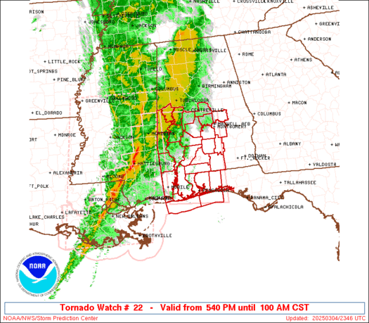
Slight Risk for severe weather on Wednesday. Damaging wind, hail, and a few tornadoes possible. In Louisiana, Mississippi, Alabama, Tennessee.
There will be some wiggle room with this outlook and I'll share the NWS SPC images as they update it. Some locations may be added or dropped as we get closer to Wednesday.
Stay tunned!
Now would be a good time to practice your severe weather satey plans.